


If you live in the West Coast of the US, wildfires are both a tragic and all-too-common part of daily life. According to the National Oceanic and Atmospheric Administration (NOAA), we had over 55,000 wildfires in the US in 2023 alone, with more than 2.5 million acres burned across the country.
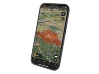
Up-to-date information is key for both wildfire safety and effective route planning, especially on off-road trips where a closed gate can make or break a day’s ride. That’s why the folks at onX have included an “Active Wildfire and Smoke” layer on their GPS and navigation apps for years, but historically that information has come from the National Interagency Fire Center (NIFC), which is often only updated once every 24 hours.

That’s all set to change according to an announcement made by onX this week. Representatives from the popular app state they’ve begun leveraging data from the folks at NASA to provide hourly updates on wildfire risks for their onX Backcountry, onX Offroad, and onX Hunt apps.
Related: Top 5 Off-Road Review - 2024 BMW F 900 GS Trophy Edition
“Every once in a while, living in the West, I see a plume of smoke appear on the horizon. But information about that fire isn’t usually available until the next day,” onX head of Cartography Lee France said. “With this ‘hot spot’ information at hand, our app users can often see fires that started just an hour ago. As a result, they can make informed decisions on how to alter their outdoor adventure plans and avoid fire hazards altogether.”

The “hot spots” France is referring to here are the secret sauce behind onX’s new technology. Starting this week, the brand is adding information provided by NASA satellites equipped with VIIRS sensors, which capture both visual and infrared images of the planet.
These infrared sensors allow onX to display areas of abnormal heat onto their maps as glowing yellow dots, which update and display long before new reports on hazard areas are released from the NIFC. This will enable off-roaders (as well as hikers, backpackers, and hunters) to get nearly real-time information on the location and movements of active fires in their area, aiding them in avoiding closures and unsafe riding conditions.
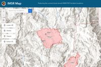
OnX says they’re also adopting a new model for their “Wildfire Smoke Layer” that pulls hourly data from the aforementioned NOAA’s “rapid refresh” weather model. This will add color-coded gradients to their maps to identify where smoke is thickest as well as the direction it’s moving to help riders plan accordingly.
“By [our] providing a higher level of smoke detail and recency, in conjunction with our Air Quality Index layer, onX app users can better understand where they can find clean air to recreate and places they should avoid,” onX senior director of Geospatial Brian Riordan said.
These updates are available now to app users at any membership level. To learn more about the onX app, you can check out their site at onxmaps.com.
/cloudfront-us-east-1.images.arcpublishing.com/octane/MUQLOVLL2ZDGFH25ILABNBXKTI.jpg)
/cloudfront-us-east-1.images.arcpublishing.com/octane/TNOU5DNE2BC57MFPMGN2EIDXAM.jpg)
/cloudfront-us-east-1.images.arcpublishing.com/octane/GTCXACQGJ5HAPDTGWUQKDEH44E.jpg)
/cloudfront-us-east-1.images.arcpublishing.com/octane/S35YGSEMEZB4BLTDJTSZPF4GLA.jpg)
/cloudfront-us-east-1.images.arcpublishing.com/octane/5UOT6HPX2JFMRJAX6EH45AR4MQ.jpg)
/cloudfront-us-east-1.images.arcpublishing.com/octane/OKWOJWAKP5EP3OACCRRWPCIX2Q.jpg)
/cloudfront-us-east-1.images.arcpublishing.com/octane/2WF3SCE3NFBQXLDNJM7KMXA45E.jpg)
/cloudfront-us-east-1.images.arcpublishing.com/octane/G4MG6OUCJNBSHIS2MVVOTPX65E.jpg)
/cloudfront-us-east-1.images.arcpublishing.com/octane/IIGGWFOTOJGB7DB6DGBXCCMTDY.jpg)
/cloudfront-us-east-1.images.arcpublishing.com/octane/QSTCM6AVEZA5JJBUXNIQ3DSOF4.jpg)
/cloudfront-us-east-1.images.arcpublishing.com/octane/U4I7G625B5DMLF2DVIJDFZVV6M.jpg)
/cloudfront-us-east-1.images.arcpublishing.com/octane/B6XD6LS6IVCQPIU6HXDJSM3FHY.jpg)
/cloudfront-us-east-1.images.arcpublishing.com/octane/ICL63FEDDRDTTMINYICCEYGMDA.jpg)
/cloudfront-us-east-1.images.arcpublishing.com/octane/FCGZHQXRBZFLBAPC5SDIQLVF4I.jpg)
/cloudfront-us-east-1.images.arcpublishing.com/octane/WNOB6LDOIFFHJKPSVIWDYUGOPM.jpg)

/cloudfront-us-east-1.images.arcpublishing.com/octane/X33NU3E525ECRHXLNUJN2FTRKI.jpg)
/cloudfront-us-east-1.images.arcpublishing.com/octane/6KKT5NNL2JAVBOXMZYS5ZO76YA.jpg)
/cloudfront-us-east-1.images.arcpublishing.com/octane/J5RKG5O455GMPGQRF2OG6LRT7A.jpg)
/cloudfront-us-east-1.images.arcpublishing.com/octane/GX2CIZKQVRH2TATDM26KFG2DAE.jpg)
/cloudfront-us-east-1.images.arcpublishing.com/octane/ZWIDYSAKQZHD5BHREMQILXJCGM.jpg)
/cloudfront-us-east-1.images.arcpublishing.com/octane/CYUHJZCTSJCH3MRAQEIKXK7SCQ.jpg)
/cloudfront-us-east-1.images.arcpublishing.com/octane/LKOFINY56FCXJCANJ5M7ZDQUBY.jpg)
/cloudfront-us-east-1.images.arcpublishing.com/octane/4NBPDACMWJH63JQYJVK3QRBDZI.jpg)