


In Colombia, if you don’t like the climate or the landscape, just keep riding; it is bound to change drastically, and very quickly.
Change is the only constant, especially here in Colombia, which has the most geographical diversity of any country on the planet. From jungles to deserts to beaches to snowcapped peaks, often in a single day. This quality results not only in a tremendous diversity of flora and fauna, but also the wide array of different gear you’ll need to take with you on your motorcycle adventure there.
Packing for this journey was not easy. My mission to document the positive actions taken to protect ecosystems and combat the illegal wildlife trade means that and remote locations in which rare and threatened species exist.
Related: Touring The Andes Mountains On An Indian Scout
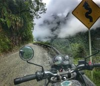
This contrast in landscapes and climate is certainly true of el Trampolín de la Muerte, "the Trampoline of Death," a stretch of dirt and gravel that connects the city of chilly, mountainous Pasto to humid, hot Mocoa in the south of Colombia. This is the narrowest stretch of the Andes, traversing the unique páramo ecosystem down in to the Amazonian jungles.
It’s hard to resist exploring a road with a name and a reputation such as this.
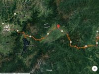
Pasto is the largest city in the south of Colombia before the border to Ecuador. Heading east from there, the road starts out with smooth pavement, winding you toward Laguna de la Cocha. This lagoon should not be missed and is a short detour from the main road. It is a beautiful, mist-covered lake with slipper-like speedboats, chilly fog draped across its quaint canals, and fresh, salmon-colored trout cooked many different ways, all delicious.
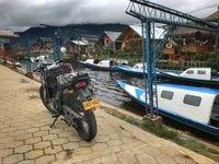
Laguna de la Cocha is a natural wetland reservoir of biological, cultural, and international importance. La Cocha is one of the largest and best preserved Andean lakes in the northern Andes. It is located southeast on the eastern slope of the mountain ridge at an elevation of 2,760 meters (8,790 feet).
There is an incredible awareness of the medicinal and spiritual quality of the plants in this area, and the indigenous people, bundled in scarves and knit ponchos, are keen to protect them and preserve their healing knowledge.
In regard to the indigenous communities who conserve the local ecosystem you’ll be respectfully ripping your bike through, you can learn about the medicinal and shamanistic value of plants at Alquimia, a school of Amazonian alchemy. It was at this school that I learned about a reserve run by a native family working to protect the balance of the Laguna de la Cocha on their property called Reserva del Buho. In addition to sharing their passed-down wisdom, they also offer locally grown and harvested food as well as accommodations.

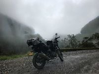
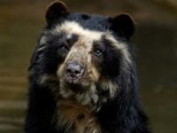
From there, the road ascends to a high altitude ecosystem, known as el páramo, home to the spectacled bear and frailejones, the only South American bear and a water gathering plant in the sunflower family, respectively. At this altitude, the temperature gauge on my bike read 17° centigrade, but I suspect the temperatures, with windchill and blanketed fog, were much lower.
The road becomes dirt and narrows after Sibundoy, a legendary town for ethnobotanists with the highest concentration of psychoactive plants in the world. Sibundoy also happens to be a great place to stop for lunch, with plenty of rotisserie cuy (guinea pig) available.

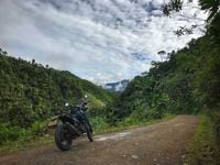
I've heard there are clear, blue skies along el Trampolín a few times a year, with views of jungle scapes, rolling seas of lush green cascading down the 1,000-meter (3,281 feet) sheer drops into the valleys below. This was not the case as I traveled, embraced by perpetual clouds and tumbling mist the whole way.
Occasionally though, there would be a break in the mist, making evident the fast pace at which it moved and revealing how the road was carved into the sides of the steep green mountains, showing the height and the precarious placement of this path less traveled.
For obvious reasons, this road is not advised in severe weather conditions. The surface of the road itself can get very slippery and the steep slopes are prone to landslides. Storms often leave this road impassable, even with a 4x4 vehicle. Hundreds of people have lost their lives along this narrow stretch of road since it was built in the 1930s to transport soldiers.
With the mist looming heavy, I lost count of the number of river crossings, as waterfalls cascade right down across the road, indifferent to its presence. Often you are crossing the same river multiple times as you snake up and down the more than 100 switchbacks and hairpin turns of these steep mountains. Depending on the amount of recent rainfall, some of the crossings can be quite deep, with large stones which are difficult to see in the riverbed. Take caution.
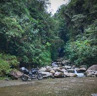
Guardrails have been put up in sections of the road, but there are still many stretches without them where there isn’t room for more than one vehicle at a time and the trucks will not wait for you to get out of the way.
When you begin the final descent, you’ll soon see banana trees exploding out of the landscape, colorful houses, and the air temperature can easily climb more than 15° centigrade from that of the páramo.
At this point, you’ve just crossed from the cool, drier mountains of Nariño into the wet, sticky jungles of Putumayo.
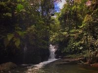
There are many notable waterfalls south of Mocoa, Fin del Mundo (End of the World) being the most famous of them all.
I had a date with the protected forests of Los Cedros in Ecuador which are being encroached upon by miners, so from the end of the world, I traveled south to cross the border.
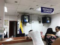
I crossed into Ecuador just south of La Hormiga. The Colombian military guard at the bridge wanted to add me on Facebook before allowing me to cross the river into Ecuador. I rode across, seeing all the welcome signs, but with no office in sight to receive passport stamps. It felt way too easy. I turned around just in case I missed something. I saw a guard lounging under an umbrella at the bridge and he told me it was a couple of kilometers ahead.
Once I arrived, I saw hundreds of Venezuelan refugees, their luggage, and their makeshift camps strewn around the perimeter of the building. There was a crowd around the entrance to the main door and it was clear that people were upset as a guard declined entry. There were sick children at a medic table crying. An officer walked me through a crowd to let me in the doors, where there was zero indication or signage for what to do next. After getting my stamp out of Colombia from the one and only woman working there (who did not seem happy), I then got in line for the Ecuadorian side and stood in the same spot for the next 2.5 hours.
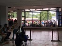
There was one woman doing all of the processing for in and out of Ecuador and she would occasionally just leave her desk, stepping into a back room, not returning for quite some time. There was no air-conditioning and my arms were full of my riding gear and documents.
The line stood still. A woman outside lost consciousness and her limp body was carried into the building.
For as long as this process took me, I still felt an incredible, almost palpable feeling of my own privilege. I had an American passport, all I needed was a stamp and I would be on my way. Who knows how long they will stay at the border and what lies for them ahead. What were the conditions like for them that they left? Without food, health care, electricity, and without hope—they were forced to leave. My heart goes out to them, though I feel such sympathy is insignificant to their challenges.
The disparity between us humans is tremendous. How awful that people can live so lavishly, so in excess, when others are so desperate and in need; that the dogs of the rich eat better than the children of the poor. I hate it.
I rolled into the nearest town, Lago Agrio, just as the sun was setting. I parked my bike and settled on the first hotel I looked at, after he offered a better room with my own bathroom and a window for the same price. Ecuador takes American dollars, which is quite a strange quality and makes the country slightly more expensive.
The next day I set out for Quito.
I ascended into the cold. I stopped for a simple meal of eggs, rice, and avocado. It was at this meal that I learned that Ecuadorians drink dehydrated instant Colombia coffee. I declined and just drank the hot water instead.
From there, wet and cold, I pressed on. I passed some huge waterfalls and arrived in the páramo. At this point on my journey I had crossed the Andes a few times already, and therefore completely underestimated the pass between Baeza and Quito.
The only time I tried to stop for a photo was to take this video, when my bike quit and barely started again. You can see how I lost traction with my foot during filming on the sublimating frost.
I had to stand up on my pegs for much of the journey just to keep warm, to keep blood flowing to my limbs. The moisture swirling about the road was totally surreal; the word “sublimation” just kept rolling through my mind.
It was like a road of dry ice, and it just kept climbing higher.
When I stopped to take a video of this otherworldly view, my motorcycle immediately died. Being carbureted, it was running extremely rough, almost not at all in the thin air. Were I not freezing and feeling the need to move on as quickly as possible, I would have adjusted it. I had to stay above 5,000 rpm just to keep the bike alive, which meant second gear most of the way.
I couldn’t tell if the sides of the road were covered in frost and the ice was sublimating, skipping the liquid phase all together, or if it was mist gathering on the edges of leaves and swirling above. I couldn’t stop to find out. My fingers and toes were completely numb and yet the road just kept climbing.
I saw many signs for spectacled bear crossing (Tremarctos ornatus, "oso anteojos" the only bear of South America, which I've named my bike after) and sent all of my motivating hope from wishing for the road to stop inclining to that of spotting one of these incredible animals.
The road then reached a point where there was zero visibility, just a wall of white with occasional swirling. I knew I had to keep going, to move through this place as fast as I could, which unfortunately was somewhat slowly, in second gear at 5,500 rpm.
Finally, a break in the white. The top ridgeline, with dry rolling mountains on the other side, sun hitting their golden grasses—a drastically different ecosystem and even with a glimpse of blue sky. I made it.
The temperature began to rapidly increase during my descent and, with it, the feeling back into my extremities.
With my day beginning in Lago Agrio at an elevation of 297 meters (974 feet) and the road reaching 4,060 meters (13,320 feet), a climb of 3,763 meters (12,346 feet) is nothing to shake a stick at.
The descent into Quito was glorious and the contrast of that mountaintop scenario with entering into civilization and city traffic felt completely bizarre.
The following day, still trying to warm up from the mountain pass, I became trapped in a sauna (after I cranked it up to 70° centigrade), perhaps one of my worst nightmares. The doorknob was broken, the inner metal components completely missing. I panicked and cut my hand trying to get the doorknob to function, bleeding all over the door. Very unfortunately, they were grinding metal outside so no one could hear my screams for help. Obviously, and thankfully, I escaped.
Seems comical to travel solo by motorcycle in such harsh conditions and then nearly meet your demise from a spa feature designed to help you relax.
If this isn’t an indication to go out and live your most daring life I don’t know what is.
/cloudfront-us-east-1.images.arcpublishing.com/octane/G4MG6OUCJNBSHIS2MVVOTPX65E.jpg)
/cloudfront-us-east-1.images.arcpublishing.com/octane/IIGGWFOTOJGB7DB6DGBXCCMTDY.jpg)
/cloudfront-us-east-1.images.arcpublishing.com/octane/QSTCM6AVEZA5JJBUXNIQ3DSOF4.jpg)
/cloudfront-us-east-1.images.arcpublishing.com/octane/U4I7G625B5DMLF2DVIJDFZVV6M.jpg)
/cloudfront-us-east-1.images.arcpublishing.com/octane/B6XD6LS6IVCQPIU6HXDJSM3FHY.jpg)
/cloudfront-us-east-1.images.arcpublishing.com/octane/ICL63FEDDRDTTMINYICCEYGMDA.jpg)
/cloudfront-us-east-1.images.arcpublishing.com/octane/FCGZHQXRBZFLBAPC5SDIQLVF4I.jpg)
/cloudfront-us-east-1.images.arcpublishing.com/octane/WNOB6LDOIFFHJKPSVIWDYUGOPM.jpg)
/cloudfront-us-east-1.images.arcpublishing.com/octane/X33NU3E525ECRHXLNUJN2FTRKI.jpg)
/cloudfront-us-east-1.images.arcpublishing.com/octane/6KKT5NNL2JAVBOXMZYS5ZO76YA.jpg)
/cloudfront-us-east-1.images.arcpublishing.com/octane/J5RKG5O455GMPGQRF2OG6LRT7A.jpg)
/cloudfront-us-east-1.images.arcpublishing.com/octane/GX2CIZKQVRH2TATDM26KFG2DAE.jpg)
/cloudfront-us-east-1.images.arcpublishing.com/octane/ZWIDYSAKQZHD5BHREMQILXJCGM.jpg)
/cloudfront-us-east-1.images.arcpublishing.com/octane/CYUHJZCTSJCH3MRAQEIKXK7SCQ.jpg)
/cloudfront-us-east-1.images.arcpublishing.com/octane/LKOFINY56FCXJCANJ5M7ZDQUBY.jpg)
/cloudfront-us-east-1.images.arcpublishing.com/octane/4NBPDACMWJH63JQYJVK3QRBDZI.jpg)
/cloudfront-us-east-1.images.arcpublishing.com/octane/KKHQHRR3FJGX7H2IPU6RALMWG4.jpg)

/cloudfront-us-east-1.images.arcpublishing.com/octane/5IOFS5JAE5FOXMNA23ZRAVVYUU.jpg)
/cloudfront-us-east-1.images.arcpublishing.com/octane/CGXQ3O2VVJF7PGTYR3QICTLDLM.jpg)
/cloudfront-us-east-1.images.arcpublishing.com/octane/OQVCJOABCFC5NBEF2KIGRCV3XA.jpg)
/cloudfront-us-east-1.images.arcpublishing.com/octane/OPVQ7R4EFNCLRDPSQT4FBZCS2A.jpg)