


Take a Polynesian naming convention, add in the European dialect and influence of the 1600s, a dash of contemporary architecture, wildlife usually found only in a zoo, some rainforest glaciers, and the ease of communicating in English—and what do you get? A tour through the most-recently discovered landmass on earth: New Zealand.
While no clear dates can be given for the island’s first inhabitants, the mythical Polynesian navigator, Kupe, was estimated to have arrived in 925 AD. European settlers “discovered” Aotearoa (“ow-tee-uh-RO-uh,” the Māori name for the islands) in 1642, led by explorer Abel Tasman and later Captain James Cook in 1769.
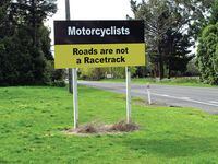
Today, the islands are under British rule. Native Māori (literally translating to local or original people) chiefs and the British Crown signed the Treaty of Waitangi in 1840, creating a diverse and vibrant concoction for governing the land and its culture. Here you’ll find breathtaking scenery, more sheep than people, and 98 octane at the pump, despite the national speed limit of a meager 100 kph (62 mph). Born and bred in the vacuum of the pale-blue South Pacific, “En-Zed” is a unique gem.
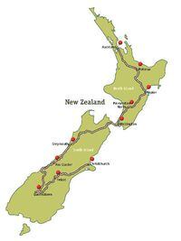
Mapping two islands into one ride is a tricky feat. What to see, how much time to spend (more!), and where to ride weigh heavily on the planning process. So I enlisted the help of some friends-of-friends who run a rental company with offices on both islands. Though the country is not much larger than Colorado in area, some days will be long in the saddle, while others will be spent on foot, bicycle, or jet boat.
The more populous island of the two, Te Ika a Māui (Māori for the fish of Māui), is the North Island (NI), where I began my trip, in the country's largest city, Auckland. The highways around Auckland are the only ones you'll see on the islands; the rest of the roads are like your favorite long way home. The South Island (SI), or Te Wai Pounamu (the waters of greenstone, jade), is the cherry on the sundae, with landscapes to die for and thousands of miles of paved and unsealed roads just waiting to be explored.
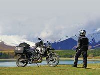
The North Island’s terrain is built around a singular volcanic high point with valleys through which the roads meander. The South Island is more strictly divided by the ridgeline of the Southern Alps (and home to the country’s highest peak, 12,316-foot Mount Cook). Roadways generally flow north to south here with the eastern routes running through low-lying pastures and farmland. The most desolate roads are on the western side of the island and narrow down to one major route along the coast, through golden fields, rainforests, and a tourism industry of glacier hiking. The island’s unique proximity of ice to rainforest makes it one of earth’s true rarities.
On The Road Again
With limited time to see everything Aotearoa has to offer, a one-way rental from the folks at Te Waipounamu Rentals fit the bill. Their locations in the two islands’ largest cities enabled me to fly into Auckland (NI), ride both islands and fly out from Christchurch (SI). Outfitted with a fresh new BMW F800GS, Givi hard sidecases, detailed maps, and plenty more suggestions, I was off and running.
Spanning the two islands are nine posted scenic routes and a few lesser routes, locally known as themed highways. The Thermal Explorer route leads from Auckland to Hawkes Bay on the southeastern shore of the NI, and is my plate of scenic morsels for my first day on the road. Departing the City of Sails on Route 1, southbound towards the growing suburb of Hamilton, this multilane highway melts into the countryside, crossing the emerald-green landscape of the Waikato region to and through Rotorua, Taupo, and on to Napier.
Roads get tighter and tighter as you approach the coast. The region around Lake Taupo is the island's recreation and thermal spa headquarters. Lord of the Rings fans will want to divert through Matamata to tour the latest Trilogy's movie set. Māori cultural centers like Te Puia in Rotorua offer the perfect crash course in native music and arts, as well as boiling mud pools and the Pohutu geyser.
With a late start, an overnight in Rotorua (roughly 150 miles from Auckland) makes a great rest, with the bustling tourism industry providing food and lodging.
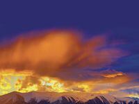
My second day on the road was beautiful, but lengthy. Having heard so much about the South Island’s beauty, I didn’t want to be delayed by the spring’s unpredictable weather—four seasons in a day, they say—so I packed on the miles. Following Route 5 out of Rotorua and through Taupo, it’s about 140 miles to the art deco wine region of Napier where I stopped for a little sightseeing and a late lunch before moseying farther south. An earthquake in 1931 leveled the town, thus the period rebuild.
Now following the Classic New Zealand Wine Trail, I’m in a region that produces 70 percent of New Zealand’s wine. Spanning two islands, this Route makes the ferry’s crossing from the land of Cabernet Sauvignon on the North Island to the South Island’s Sauvignon Blanc country in Blenheim, Marlborough. If wine tasting is your thing, this stretch could take you a week to absorb, but in my case, I thirst for another fancy (today, anyway).
From Napier to the ferry’s port in the capital city of Wellington is another 200 miles, so I rested for the night midway in the popular layover city of Palmerston North, where I shared a hotel with a rugby team also passing through. In the morning it’s off to Wellington and a rest day.
Home to Lord of the Rings director Peter Jackson, Wellington is more than just a port city on the Cook Strait. It’s maybe the coolest capital city I have ever seen, with its friendly, walkable city center, bustling waterfront complete with water taxis, museums, and restaurants—there’s even a waterfront camper-van site.
However, for sheer confusion, the matrix of Wellington’s city streets rivals those of Boston and Washington D.C., combined. Untangling the network of one-way streets to find my hotel took more than just the usual route sorting. Maps both paper and digital were nary a help along The Terrace, where roads are stacked on top of each other, traveling in opposite directions, making a mockery of my navigation skills.
Eventually I found a place to offload so I could poke around town. I’ll suggest Fidel’s on Cuba Street for a stiff coffee and the alternative crowd. Closer to the water is Courtenay Place for more mainstream food and entertainment. Find The Malt House for the best respite and local brews.
Up, Up, and A-wait
Next time I fired up the bike, it was time to make the water passage to the South Island, and had I known about the busted ferry, I could have slept another four hours. As it was, I got to dig deeper into my HEMA maps while waiting for the next available ship. The crossing itself took 3.5 hours. Onboard Wi-Fi helps pass the time, but at $7 for a 40MB download, it can get expensive. Note: Carry your own tie-downs if you can; those on the ship are often in terrible condition.
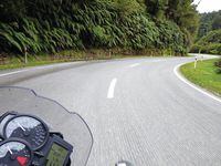
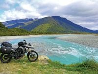
Before the third day of riding was done, my heart had found peace. One of my top ride days of all time covered Routes 63, 6, and 69 through Picton, Blenheim and Westport. The roads are not specifically named with any theme, and the lack of tourist attractions meant a lack of tourists, affording free-flowing passage along silky smooth ribbons of wide-open asphalt. Weaving a path past snow-capped peaks, through lush green valleys and between numerous named forests and national parks, this was 200-plus miles of bliss all the way to the golden fields of the coast. (Fuel up in Blenheim!)
By the cold and dreary town of Greymouth, it was time again to find a solid meal and some shelter. The streets roll up early in New Zealand and after 8 p.m., it’s hard to find much of anything, even in cities. But I did find a tavern hotel with a pleasant staff and a top-quality eatery. Surprisingly, the restaurant tucked into The Railway Hotel, along the Mawhera Quay, outshined the exterior of the building, and was a delicious surprise. I met the first Americans I’d seen in almost two weeks in the bar.
Now on the West Coast Touring Route, number 6, the greenstone shopping capital of Hokitika is your first stop. For me it was a welcome break and a chance to snag gifts for the ladies in my life. Fuel up, as stations are pretty thin over the next 80 to 100 miles, and they close up after nightfall. The next major town is Franz Josef, the more advertised and popular of the two glacier-hiking centers along the coast road. The Franz is the only glacier you can see from a distance, so if you haven’t the time for a hike but want to get a picture of the ice, check out the local access road.
I took the half-day hike on the less-trafficked Fox Glacier 15 miles down the road and had a great time. Despite the falling rain on the roadway, the ice creates its own weather system and we didn’t see any rain until we returned to town. Both glaciers, crawling down the western slope of Mount Cook, are within the Westland National Park. There are no fees for the park but guided hikes on the ice will run you $100 or more.
Basking in the grandeur of the west lands, and drying out from the ride, I stayed the night in the small community around the base of the glacier. The Southern Island’s epicenter for action sports and scenic wonder, Queenstown, is only 200 miles away, but it will take me all day to ride there with the numerous unsealed roads and ocean vistas and mountain towns calling my name. One-lane bridges will keep the ride interesting.
The West Coast Touring Route ends in the fishing village of Haast. That’s where the road turns away from the coast and into the mountains, still carrying Route number 6. The remaining coastline to the southern end of the island is parkland and there are no more through roads. Climbing nearly 7500 feet through the Gates of Haast, it’s not until Wanaka that you’ll find much of anything to do but ride and enjoy the scenery.
Between beautiful lakeside Wanaka and Queenstown, take the mountain pass through Cadrona and stop off at the Cadrona Hotel for a snack if not a meal. You will not be disappointed by this little historical site’s cozy interior and inviting backyard eatery. Arrowtown is an authentic cowboy-town attraction a few miles shy of the Queenstown metropolis. Gold was first discovered in 1862 in the nearby Shotover River, which proved to be one of the richest gold-bearing rivers in the world.
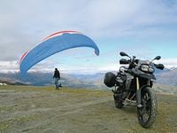
Park it in Queenstown and book up your next adventure, or drop your tail end down and rest a few days. I, of course, hopped a jetboat ride with the original and oldest company in the country, KJet, right there on the lakefront. I took a ride up the Skyline for lunch and some stellar photographs of the lake and alpine scenery. Then, before cooking up my own dinner back at the Best Western Cranberry Court, I made a run up Skippers Road towards Coronet Peak to get a few twisties in before sundown. Being spring, of course the locals were still skiing up there, but while I was taking photos a van full of parasailers pulled up and leapt off the cliff. It’s a crazy place!
The Final Stretch
The ride to Christchurch is about 300 miles and 6 hours if you have to make it there in one day. But I cut it in half and stayed in Twizel, along the shores of Lake Pukaki, and took the spur trip out to Mount Cook National Park. The next morning I made the final blast up to Christchurch, turned in the GS and raced off to the airport.
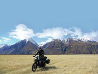
If your mental image of New Zealand is rocky snow-capped mountains above emerald green fields and sparkling blue waters, then the ride between Queenstown and Geraldine (about 40 miles short of Christchurch) is the best the islands have to offer. Winding roads and staggering scenery—never a slow stretch or city traffic to tangle with—the high plains of the Canterbury state are breathtaking. And yes, I know I’ve said that a lot in this story and I apologize, but you’ll know what I mean after your first visit. Then you’ll be the one telling everyone how amazing New Zealand is to ride.


/cloudfront-us-east-1.images.arcpublishing.com/octane/TNOU5DNE2BC57MFPMGN2EIDXAM.jpg)
/cloudfront-us-east-1.images.arcpublishing.com/octane/GTCXACQGJ5HAPDTGWUQKDEH44E.jpg)
/cloudfront-us-east-1.images.arcpublishing.com/octane/S35YGSEMEZB4BLTDJTSZPF4GLA.jpg)
/cloudfront-us-east-1.images.arcpublishing.com/octane/5UOT6HPX2JFMRJAX6EH45AR4MQ.jpg)
/cloudfront-us-east-1.images.arcpublishing.com/octane/OKWOJWAKP5EP3OACCRRWPCIX2Q.jpg)
/cloudfront-us-east-1.images.arcpublishing.com/octane/2WF3SCE3NFBQXLDNJM7KMXA45E.jpg)
/cloudfront-us-east-1.images.arcpublishing.com/octane/G4MG6OUCJNBSHIS2MVVOTPX65E.jpg)
/cloudfront-us-east-1.images.arcpublishing.com/octane/IIGGWFOTOJGB7DB6DGBXCCMTDY.jpg)
/cloudfront-us-east-1.images.arcpublishing.com/octane/QSTCM6AVEZA5JJBUXNIQ3DSOF4.jpg)
/cloudfront-us-east-1.images.arcpublishing.com/octane/U4I7G625B5DMLF2DVIJDFZVV6M.jpg)
/cloudfront-us-east-1.images.arcpublishing.com/octane/B6XD6LS6IVCQPIU6HXDJSM3FHY.jpg)
/cloudfront-us-east-1.images.arcpublishing.com/octane/ICL63FEDDRDTTMINYICCEYGMDA.jpg)
/cloudfront-us-east-1.images.arcpublishing.com/octane/FCGZHQXRBZFLBAPC5SDIQLVF4I.jpg)
/cloudfront-us-east-1.images.arcpublishing.com/octane/WNOB6LDOIFFHJKPSVIWDYUGOPM.jpg)
/cloudfront-us-east-1.images.arcpublishing.com/octane/X33NU3E525ECRHXLNUJN2FTRKI.jpg)
/cloudfront-us-east-1.images.arcpublishing.com/octane/6KKT5NNL2JAVBOXMZYS5ZO76YA.jpg)
/cloudfront-us-east-1.images.arcpublishing.com/octane/J5RKG5O455GMPGQRF2OG6LRT7A.jpg)
/cloudfront-us-east-1.images.arcpublishing.com/octane/GX2CIZKQVRH2TATDM26KFG2DAE.jpg)
/cloudfront-us-east-1.images.arcpublishing.com/octane/ZWIDYSAKQZHD5BHREMQILXJCGM.jpg)
/cloudfront-us-east-1.images.arcpublishing.com/octane/CYUHJZCTSJCH3MRAQEIKXK7SCQ.jpg)
/cloudfront-us-east-1.images.arcpublishing.com/octane/LKOFINY56FCXJCANJ5M7ZDQUBY.jpg)
/cloudfront-us-east-1.images.arcpublishing.com/octane/4NBPDACMWJH63JQYJVK3QRBDZI.jpg)
/cloudfront-us-east-1.images.arcpublishing.com/octane/KKHQHRR3FJGX7H2IPU6RALMWG4.jpg)